Sousou no Frieren Map - Journey Beyond My Sanity
Map creator
AnzhcDescription
\## Landmarks
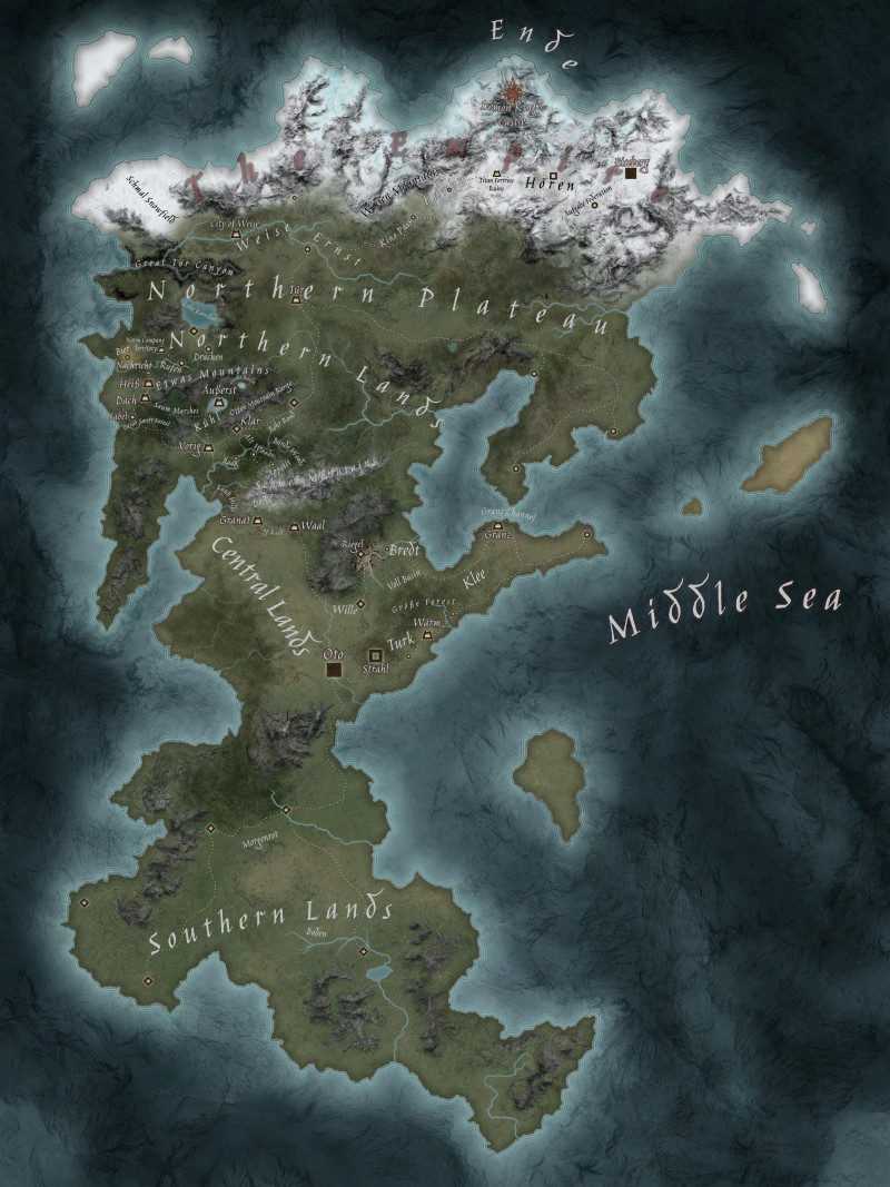
Okay, so... Beyond Tor Canyon there are NO reliable named landmarks on official references.
Cities and villages taht are not near any of the names are superficial and might as well not exist. They are created from official reference, where roads end \*somewhere\*, but no landmark exist. Such is the case with points on the east part of the continent.
Southern lands don't have any landmarks references, or description i could easily find, except 2 names, which i don't know what they refer to, as they don't coincide with the few roads and marked landmarks visible on official art.
\## Frieren's Journey beyond my sanity
It starts off really nicely, until we get to Wille, then we rubberband to Riegel to get Stark, but no biggie, little detour... I did double check, and that is where those points are located on official map, so can't blame me...
Then we get to beyond Shwer Mountains and start to jump around. All those places are named on official map, so i guess it's just like that.
Same goes for everything covered by season 1 of anime. Beyond that there are no official landmarks, except Korridor and Tor. Starting from Saum Marshes and all the way till Eiseberg - pure imagination and piecing together bits from fandom wiki, which cross-references anime (till Tor Canyon(apparently ep38, i haven't started season 2 yet) and all the way to the Eiseberg (chapter \~122 of manga), at which point it seem to end right now/is ongoing, so mapping beyond that point doesn't seem to be possible for me.
At first, looking at how it described that after Saum Marshes they split to go towards Northern Plateau, i thought they went on the road to the right, towards Tur, as it only makes sense, as Tur is described as being \*\*in middle of Northern Lands\*\*, so i thought that Lake Korridor was also part of it. Both Tur and Lake Korridor are referenced in official map. But no, apparently that lake is already part of Northern Plateau, and im concluding that it has weird non-euclidean geometry that goes through another dimension to warp around middle of Northern Lands, to come out on other side. (Or fandom wiki just had a mistake, but that's not as schizo so i don't like that variant).
I mapped it all through the right part of continent, so violation of time-space continuum was even stronger, where Frieren and her party would teleport from right part of continent from Dachen to Korridor, then skip entirety of shmal-Weise-Ernst and go straight to Kino Pass, which, admittedly, given how path is going from official source, it probably can be considered canon, but i remapped it to be on the more physically plausible, but probably too dense path, through the left part of the continent.
I wonder if they will include more info down the line about geography of the world beyond just locations, but more maps.
Feel free to clone and fix whatever mistakes i made, probably tons.
Actions
Related Arts
Sousou no Frieren Map - Journey Beyond My Sanity
[https://inkarnate.com/m/PdoOpo](https://inkarnate.com/m/PdoOpo) \## Landmarks Okay, so... Beyond...
More like this
Port Sorrow Shipyard (EA: Day/Night; Individual Buildings; Full res. in description)
Preparing for my pirate campaign and have made a massive shipyard map, + zoomed in versions of the p...
I created a Dark Souls inspired map and setting, the Thrice-Cursed Lands of Avak'Emnar (Free Map Pack) (No AI) (OC)
# Map Details The map pack for this week is one heavily inspired by the Dark Souls video games. Tha...
![Town With Interiors [49x33] [Battle Map] [No AI] [OC] [Art] + full map with variants preview [92x69]](https://images.rpgartstash.com/thumb/orNDY6en3W5hXfxDekk0GKMzBvNz2WGqKxmNriuy.jpg)
Town With Interiors [49x33] [Battle Map] [No AI] [OC] [Art] + full map with variants preview [92x69]
The Seven Hells
This is my version of Hell for the cosmology of my homebrew world. My party accidentally sold their...
![3 Witch Island [World Map]](https://images.rpgartstash.com/thumb/Y6SLdi5XfPzrohexaHO6a5ysZWP5IXkYGsnndKVL.jpg)
3 Witch Island [World Map]
I tried to have a theme while designing this map. I like to keep my maps open to interpretation, bu...
My first map W.I.P
My buddies wanna do a Dark Fantasy homebrew campaign 🥹 this is still W.I.P but would love some poin...
![Plunging Torrents [PotA] Free dungeon maps (223x226 tiles)](https://images.rpgartstash.com/thumb/ILkxj9gtK9e9OX2ElnFW9AlBFz9yG1r98vIh3mks.jpg)
Plunging Torrents [PotA] Free dungeon maps (223x226 tiles)
*"Dangerous waterfalls, sudden deluges, and weird elemental effects fill the Plunging Torrents, a ca...
Zooming in on the World Map of Aridora.
Sharing some close-ups from my latest fantasy map after a few people mentioned the details were hard...